WORLD BUILDER
The web-native spatial operating system for the physical world. Create, publish and operate high-fidelity digital twins from a standard browser.
From one object to a nation
The same platform holds a single asset, a smart building, a stadium, a port, a city and, in time, nationwide infrastructure.
- Object
- Room
- Floor
- Building
- Site
- District
- City
- Nation
What WORLD BUILDER is
It is not a 3D viewer, a game-engine project, a GIS map or a dashboard layer. WORLD BUILDER brings the whole life of a digital twin into one browser-based environment.
WORLD BUILDER turns the spatial reconstruction engines of VIZZIO, and the sensing, video intelligence and operational AI of POLYTRON, into one platform that customers, partners and system integrators can build on themselves.
Digital twins stop being bespoke engineering projects. They become a repeatable web workflow that scales across cities, campuses, stadiums, ports, ministries and national command centres.
One platform, the whole lifecycle
- 01
Ingest
3D models, GIS layers, CAD, point clouds, video and sensor feeds.
- 02
Process
Validation, optimisation, tiling and levels of detail.
- 03
Author
Build and edit the twin in a browser-based 3D editor.
- 04
Publish
Release a scene as a web-accessible digital twin.
- 05
Stream
Progressive loading, from a single room to a whole city.
- 06
Integrate
Bind live data, cameras and enterprise systems to objects.
- 07
Operate
A live common operating picture for command centres.
- 08
Query
Search the scene by place, asset, status or event.
- 09
Export
Web-ready packages, APIs, SDKs and embeddable views.
No game engine required
Most high-fidelity digital twins still depend on Unreal Engine or Unity, and on the scarce specialists those tools need. WORLD BUILDER removes that dependency.
- No Unreal Engine to install.
- No Unity application to build.
- No game-engine pipeline to maintain.
- No bespoke software project for every deployment.
- Faster deployment
- Lower development cost
- Easier to staff
- Works with the web you already run
- Scales from one site to many
Seven modules
Object capture, indoor scanning, satellite city modelling, CCTV, IoT and enterprise data all plug into one composable platform.
The organisational foundation. Digital twin projects are managed by tenant, client, geography, asset class or deployment.
- Multi-tenant workspaces that keep organisations, customers and departments apart
- A project dashboard showing status, assets, data sources and publishing state
- Role-based access, from owner and editor to operator and external partner
- Templates for stadiums, ports, campuses, command centres and cities
- Version history and an audit log of every import, export and publish
Import, process, normalise and register 3D and geospatial assets from many sources.
- Drag-and-drop upload and batch import of whole model libraries
- Validation of format, coordinate system, polygon count and textures
- Automatic optimisation: mesh decimation, texture compression, tiling and levels of detail
- Coordinate assignment in WGS84, local, building or custom site systems
- AI tagging and metadata extraction for buildings, roads, rooms and equipment
The heart of the product. Digital twins are built and edited directly in the browser.
- A browser-based 3D editor to navigate, place, transform and organise assets
- A scene hierarchy from world, city and district down to floor, room and object
- A layer manager for GIS, 3D, CCTV, IoT, annotations and geofences
- Annotation and geofence tools for zones, perimeters and hazard areas
- Placement of cameras, sensors and edge devices with their coverage cones
- Measurement of distance, area, height, volume and line of sight
An authored twin becomes a web-ready, streamable and embeddable experience.
- One-click publishing of a scene as a web-accessible digital twin
- Publish profiles from mobile and kiosk to command centre
- Level-of-detail streaming by distance and camera position
- Web-ready packages for system integrators and dashboard teams
- An embeddable viewer by iframe, SDK or component
- Private, shared or public publishing, under your own domain
System integrators and customers connect their own data sources, without waiting on VIZZIO engineers.
- A guided data source wizard for REST, MQTT, WebSocket, databases, GIS and video streams
- Live data binding of a sensor, camera, record or endpoint to a 3D object
- Webhook ingestion of alerts and events from other systems
- A real-time layer for telemetry, alerts, heatmaps and moving objects
- An API key manager for credentials, tokens and webhook addresses
- A JavaScript and TypeScript SDK for custom dashboards
WORLD BUILDER does not only display 3D assets. It fuses live video intelligence into the twin.
- A registry of CCTV, POLYTRON 360 cameras, mobile cameras, drones and edge devices
- Cameras placed in the scene with position, height, orientation and field of view
- Live video panels, and streams pinned to the camera they come from
- AI detection overlays for people, vehicles, intrusion, crowd density and more
- Every AI event mapped to its place in the 3D twin
- A 360 degree sphere view inside a navigable 3D interface
More than an editor. Ask questions of the twin, find assets and reason over the environment.
- Natural language scene search, such as "Show me all cameras covering Gate 3"
- A spatial query engine by location, asset type, risk, sensor status or zone
- AI classification of objects, spaces, roads, rooms, equipment and sensors
- Incident summaries drawn from many video and sensor alerts
The platform at a glance
- Ingest
- Process
- Author
- Publish
- Stream
- Integrate
- Operate
- Query
- Export
What goes in
- 3D models
- GIS
- CAD and BIM
- Point clouds
- Video
- IoT
- Live feeds
The platform
Fully Browser-based. No Game Engine needed.Native-like Desktop 60 FPS Performance
- Data ingestion engine←driven by Workspace and project management
- Spatial data processing layer←driven by Asset ingestion and conversion pipeline
- Authoring and publishing studio←driven by Web-native 3D scene designer
- Web 3D runtime and streaming core←driven by Real-time publishing and CAD pipeline
- Spatial intelligence and AI copilot←driven by Live data stream and telemetry connector
- API gateway and multi-tenant access←driven by CCTV, video and sensor feeds from POLYTRON
- Command and control dashboard suite←driven by Conversational AI copilot agent
- Frontend
- React, Next.js, TypeScript, WebGL, WebGPU
- Backend
- REST, GraphQL, microservices, Kubernetes
- Core services
- Identity, projects, assets, processing, scene, publishing, integration, real-time, camera, sovereign AI, audit logs, reporting
What comes out
- API and webhook
- Enterprise apps
World model
- Object
- Room
- Building
- Campus
- City
- Nation
Roadmap
- Internal alphaMVP, private beta
- Command Centre editionMVP, enterprise
- AI-native spatial OSPlatform
- National-scale platformNational programme
Everything comes in
- POLYVIEWSmartphone video of an objectHigh-fidelity 3D object model
- REALSPACE360 degree walk-and-scan footageIndoor and outdoor spatial reconstruction
- EARTH.AISatellite imageryCity-scale 3D models
- Third-party 3DGLB, glTF, OBJ, FBX, USDZWeb-optimised 3D asset
- GISGeoJSON, shapefile, KML, DEM, raster tilesSpatial layer
- CAD and BIMIFC, RVT export, DWG and DXF conversionBuilding and asset layer
- Point cloudLAS, LAZ, PLY, E57Streamable point cloud
- VideoCCTV, RTSP, WebRTC, recorded videoLive and recorded video layer
- IoTMQTT, HTTP, OPC-UA adapterSensor telemetry layer
See it running
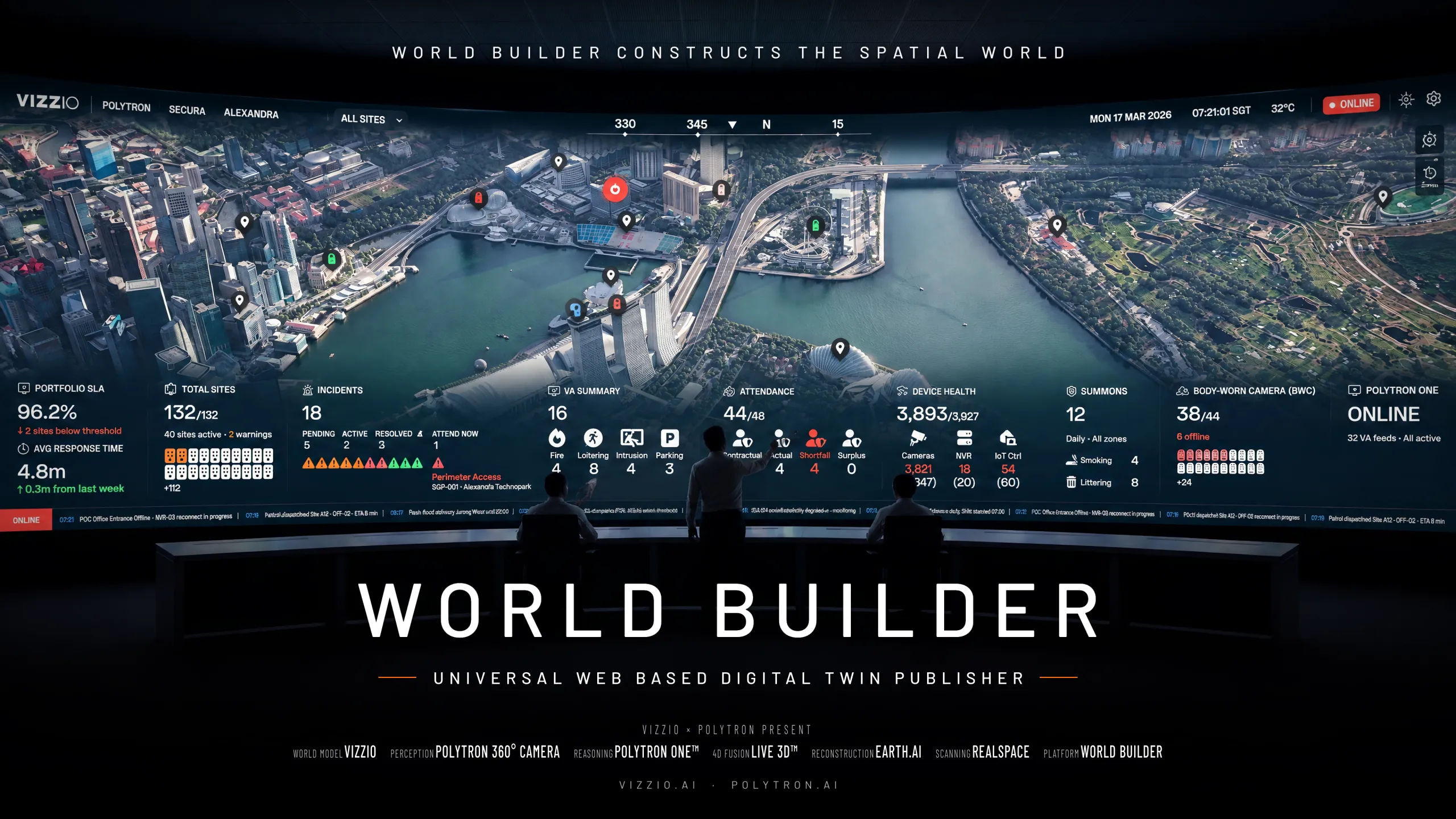
Built for those who run places
Governments and ministries
Sovereign digital infrastructure, smart city operations and national situational awareness.
Telecom operators
Platform licensing, managed services and smart city solutions.
System integrators
Faster deployment, reusable templates and less dependence on engineering.
Infrastructure owners
Operational efficiency, safety, security and visibility of every asset.
Real estate and campus owners
Building intelligence, security, energy optimisation and tenant experience.
Defence and homeland security
A 3D common operating picture, camera and sensor fusion, and restricted-zone monitoring.
Deployed where your data must live
01
SaaS cloud
Fully managed and reached through the browser. The quickest way to start, run a pilot and scale across sites.
02
Private cloud
Runs in the cloud you choose, with dedicated compute, private networking and your own storage and identity.
03
Sovereign cloud
Hosted in a locally approved cloud that meets national rules on data residency, access and cybersecurity.
04
Air-gapped package Planned
A self-contained package for restricted or disconnected sites, updated through controlled import and export.
Built in stages
WORLD BUILDER is not trying to become a complete spatial operating system in one release. Each stage strengthens the foundation for the next.
- 01Viewer
- 02Authoring platform
- 03Publishing platform
- 04Integration platform
- 05Command centre
- 06AI-native spatial operating system
Make the physical world programmable
Tell us where. We will show you what we can do.
Request Demo